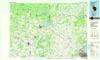
1984 Map of Shawano
USGS Topo · Published 1985About this map
The Menominee Indian Reservation and Stockbridge-Munsee Indian Reservation anchor the northern reaches of this mid-1980s landscape, where dense woodlands give way to the agricultural plains of northeast Wisconsin. The city of Shawano serves as the central hub, situated at the outlet of Shawano Lake and the confluence of the Wolf River and Red River. This period shows a well-established transportation network, with the Chicago and North Western rail lines cutting through the territory to link settlements like Bonduel, Clintonville, and Gresham.
Find a feature on this map
163 named features on this map. Tap any name to fly to it.
Don’t see what you’re looking for? This feature index may not catch every label — zoom into the map to look around manually.
Map Details
Editions of this 1984 Shawano Map
2 editions found
Other maps of this area

1939 · Porterfield
USGS Topo · 1:48,000

1941 · Coleman
USGS Topo · 1:48,000

1942 · Coleman
USGS Topo · 1:48,000

1942 · Breed
USGS Topo · 1:48,000

1942 · Porterfield
USGS Topo · 1:48,000

1950 · Coleman
USGS Topo · 1:48,000

1952 · Antigo
USGS Topo · 1:48,000

1952 · White Lake
USGS Topo · 1:48,000

1952 · Langlade
USGS Topo · 1:48,000

1952 · Mountain
USGS Topo · 1:48,000