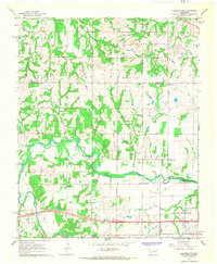
1967 Map of Shawnee NE
USGS Topo · Published 1968About this map
The North Canadian River meanders across this Central Oklahoma landscape, marking a significant geographic divide between the northern timbered uplands and the river valley. In the late 1960s, this area was a patchwork of agricultural land and active petroleum extraction, evidenced by the West Bellemont Oil Field and scattered Oil Wells. Small rural communities such as Bellemont and Garden Grove serve as local anchors, while the presence of the McConnel Memorial Ch, Nagowee Ch, and several family or community burial grounds like Wakole Cem and Bruner Cem provide vital touchstones for genealogical research. The map captures a moment when the rural road network, including Robinson Rd, connected these dispersed settlements across the Lincoln and Pottawatomie county lines.
Find a feature on this map
31 named features on this map. Tap any name to fly to it.
Don’t see what you’re looking for? This feature index may not catch every label — zoom into the map to look around manually.
Map Details
Editions of this 1967 Shawnee NE Map
This is the sole edition of this map. No revisions or reprints were ever made.
Other maps of this area

1896 · Seminole and Prague
USGS Topo · 1:125,000

1905 · Chandler
USGS Topo · 1:62,500

1907 · Chandler
USGS Topo · 1:62,500

1909 · Shawnee
USGS Topo · 1:62,500

1929 · Stroud
USGS Topo · 1:62,500

1932 · Stroud
USGS Topo · 1:62,500

1954 · Oklahoma City
USGS Topo · 1:250,000

1957 · Oklahoma City
USGS Topo · 1:250,000

1963 · Oklahoma City
USGS Topo · 1:250,000

1967 · Prague SW
USGS Topo · 1:24,000