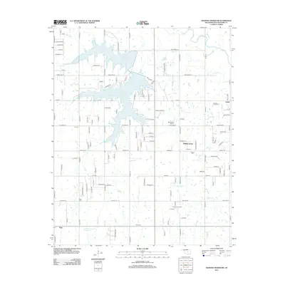
2012 Map of Shawnee Reservoir
USGS Topo · Published 2012About this map
Shawnee Reservoir dominates the northern landscape of this Pottawatomie County region, its irregular shoreline reaching into the small communities of Ingram and Pink. The map documents a blend of rural residential growth and legacy agriculture, with the town of Bethel Acres serving as a central hub. Notable for family historians, the area is dotted with small burial grounds including Blackburn Chapel Cem, Bethel Cem, and Hopewell Cem. The landscape reflects the importance of local water systems like Squirrel Cr and Jim Cr, alongside modern infrastructure such as the Centerpoint Oil Field and the Jazz Ranch Airport. This 2012 survey provides a clear view of the road network and land use near the N Canadian River during a period of steady suburban development.
Find a feature on this map
111 named features on this map. Tap any name to fly to it.
Don’t see what you’re looking for? This feature index may not catch every label — zoom into the map to look around manually.
Map Details
Editions of this 2012 Shawnee Reservoir Map
This is the sole edition of this map. No revisions or reprints were ever made.
Other maps of this area

1896 · Seminole and Prague
USGS Topo · 1:125,000

1898 · Purcell
USGS Topo · 1:125,000

1907 · Maud
USGS Topo · 1:62,500

1908 · Maud
USGS Topo · 1:62,500

1909 · Shawnee
USGS Topo · 1:62,500

1910 · McComb
USGS Topo · 1:62,500

1930 · McLoud
USGS Topo · 1:62,500

1954 · Oklahoma City
USGS Topo · 1:250,000

1956 · Harrah
USGS Topo · 1:24,000
1956 · Stella
USGS Topo · 1:24,000