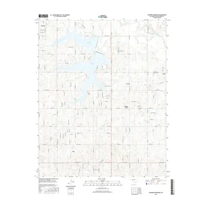
2016 Map of Shawnee Reservoir
USGS Topo · Published 2016About this map
Shawnee Reservoir anchors this landscape in Pottawatomie County, its irregular shoreline reaching into a complex network of residential roads and small rural communities. The map captures the interface between the growing outskirts of McLoud and Bethel Acres, where modern subdivisions meet established local landmarks. To the east, Gaddy and Blackburn Chapel Cem mark a quieter rural pocket, while the south is defined by the crossroads at Pink. The map is particularly useful for genealogists, as it preserves the locations of numerous historic burying grounds such as Hopewell Cem, Ray Cem, and Black Cem, many situated along the creeks that feed the North Canadian River basin, including Squirrel Cr and Lost Cr.
Find a feature on this map
119 named features on this map. Tap any name to fly to it.
Don’t see what you’re looking for? This feature index may not catch every label — zoom into the map to look around manually.
Map Details
Editions of this 2016 Shawnee Reservoir Map
This is the sole edition of this map. No revisions or reprints were ever made.
Other maps of this area

1896 · Seminole and Prague
USGS Topo · 1:125,000

1898 · Purcell
USGS Topo · 1:125,000

1907 · Maud
USGS Topo · 1:62,500

1908 · Maud
USGS Topo · 1:62,500

1909 · Shawnee
USGS Topo · 1:62,500

1910 · McComb
USGS Topo · 1:62,500

1930 · McLoud
USGS Topo · 1:62,500

1954 · Oklahoma City
USGS Topo · 1:250,000

1956 · Harrah
USGS Topo · 1:24,000
1956 · Stella
USGS Topo · 1:24,000