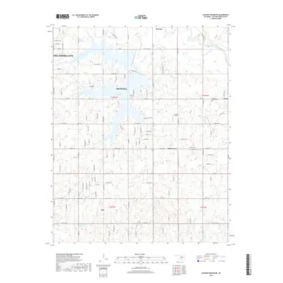
2018 Map of Shawnee Reservoir
USGS Topo · Published 2018About this map
The Shawnee Reservoir serves as the central geographic anchor for this region of central Oklahoma, where the city of Shawnee meets the eastern outskirts of Oklahoma City. This landscape is defined by the dendritic drainage patterns of the North Canadian River and its numerous tributaries, including S Deer Cr, Squirrel Cr, and Dance Cr. The map reveals a transition from denser urbanized developments toward the rural-suburban character of Bethel Acres and the community of Pink. A significant number of localized burial grounds, such as Blackburn Chapel Cem and Hopewell Cem, are distributed across the land divisions of t10n r2e and t9n r3e, providing essential coordinates for genealogical research. The inclusion of the Jazz Ranch Airport and an extensive network of county roads like New Hope Rd and Hardesty Rd illustrates the modern infrastructure integrated into this historic tribal land area.
Find a feature on this map
55 named features on this map. Tap any name to fly to it.
Don’t see what you’re looking for? This feature index may not catch every label — zoom into the map to look around manually.
Map Details
Editions of this 2018 Shawnee Reservoir Map
This is the sole edition of this map. No revisions or reprints were ever made.
Other maps of this area

1896 · Seminole and Prague
USGS Topo · 1:125,000

1898 · Purcell
USGS Topo · 1:125,000

1907 · Maud
USGS Topo · 1:62,500

1908 · Maud
USGS Topo · 1:62,500

1909 · Shawnee
USGS Topo · 1:62,500

1910 · McComb
USGS Topo · 1:62,500

1930 · McLoud
USGS Topo · 1:62,500

1954 · Oklahoma City
USGS Topo · 1:250,000

1956 · Harrah
USGS Topo · 1:24,000
1956 · Stella
USGS Topo · 1:24,000