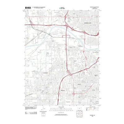
2009 Map of Shawnee
USGS Topo · Published 2009About this map
Kansas River flows through this 2009 record of the western Kansas City suburbs, separating the northern neighborhoods of Muncie and Turner from the developed residential blocks of Shawnee and Merriam to the south. The landscape is a mix of dense suburban housing and industrial corridors, notably along the Turner Diagonal Fwy and the sprawling rail yards in Argentine. Historical and cultural sites are scattered throughout, including the Wyandotte National Burying Ground and Tensquatawa Burial Ground, reflecting the region's complex heritage. Local leisure and research are represented by the Milburn Golf and Country Club and the Kansas State University Research and Extension Center, while water management features like the Pierson Park Dam and Black Swan Dam illustrate the local terrain's modification. These details capture the character of eastern Kansas as it navigated the start of the twenty-first century.
Find a feature on this map
54 named features on this map. Tap any name to fly to it.
Don’t see what you’re looking for? This feature index may not catch every label — zoom into the map to look around manually.
Map Details
Editions of this 2009 Shawnee Map
This is the sole edition of this map. No revisions or reprints were ever made.
Other maps of this area

1887 · Olathe
USGS Topo · 1:125,000

1890 · Kansas City
USGS Topo · 1:125,000

1893 · Olathe
USGS Topo · 1:125,000

1894 · Kansas City
USGS Topo · 1:125,000

1934 · Bonner Springs
USGS Topo · 1:48,000

1934 · Grandview
USGS Topo · 1:24,000

1934 · Shawnee
USGS Topo · 1:24,000

1934 · Edwardsville
USGS Topo · 1:24,000

1934 · Wolcott
USGS Topo · 1:24,000

1935 · Olathe
USGS Topo · 1:24,000