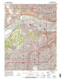
1991 Map of Shawnee
USGS Topo · Published 1995About this map
The Kansas River carves a sweeping arc through this landscape, serving as a historic divider between the industrialized bottoms of Turner and Argentine and the northern reaches of Kansas City. This 1991 revision shows the dense infrastructure of the Atchison Topeka and Santa Fe RR corridors alongside a concentrated network of memorial sites including Mt Calvary Cem, St Johns Cem, and the expansive Maple Hill Cemetery. South of the river, the transition from industrial riverfront to suburban development is evident as one moves through Shawnee, Merriam, and into the residential grids of Overland Park and Mission. Local institutional landmarks like the School for the Blind and Central Seminary remain prominent features in the urban fabric of the era.
Find a feature on this map
52 named features on this map. Tap any name to fly to it.
Don’t see what you’re looking for? This feature index may not catch every label — zoom into the map to look around manually.
Map Details
Editions of this 1991 Shawnee Map
This is the sole edition of this map. No revisions or reprints were ever made.
Other maps of this area

1887 · Olathe
USGS Topo · 1:125,000

1890 · Kansas City
USGS Topo · 1:125,000

1893 · Olathe
USGS Topo · 1:125,000

1894 · Kansas City
USGS Topo · 1:125,000

1934 · Bonner Springs
USGS Topo · 1:48,000

1934 · Grandview
USGS Topo · 1:24,000

1934 · Shawnee
USGS Topo · 1:24,000

1934 · Edwardsville
USGS Topo · 1:24,000

1934 · Wolcott
USGS Topo · 1:24,000

1935 · Olathe
USGS Topo · 1:24,000