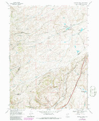
1968 Map of Shearing Corral
USGS Topo · Published 1986About this map
Union Pacific rail lines dominate the southeastern corridor of this high-altitude landscape, following the deep cut of Echo Canyon through the borderlands of Rich, Morgan, and Summit Counties. This 1968 survey (photorevised in 1986) illustrates a rugged interior defined by a network of ranching infrastructure and water management within the Wasatch-Cache National Forest. Named landmarks like Shearing Corral Canyon and the Shearing Corral Reservoir point to the area's historic sheep-herding industry. The map reveals the intricate drainage systems of Crane Creek and Suttons Creek, punctuated by industrial additions such as pipelines and a Pumping Sta. Narrow passages like Tunnel Hollow and Slaughterhouse Canyon branching off the main canyon reveal the challenging topography that guided early transportation routes through the northern Utah mountains.
Find a feature on this map
30 named features on this map. Tap any name to fly to it.
Don’t see what you’re looking for? This feature index may not catch every label — zoom into the map to look around manually.
Map Details
Editions of this 1968 Shearing Corral Map
2 editions found
Other maps of this area

1954 · Ogden
USGS Topo · 1:250,000

1958 · Ogden
USGS Topo · 1:250,000

1960 · Ogden
USGS Topo · 1:250,000

1964 · Francis Canyon
USGS Topo · 1:24,000
1964 · Heiners Creek
USGS Topo · 1:24,000

1968 · Wahsatch
USGS Topo · 1:24,000
1968 · Porcupine Ridge
USGS Topo · 1:24,000

1968 · Shearing Corral
USGS Topo · 1:24,000

1968 · Mc Kay Hollow
USGS Topo · 1:24,000

1968 · Peck Canyon
USGS Topo · 1:24,000