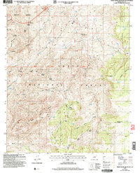
2004 Map of Sheep Basin Mountain
USGS Topo · Published 2006About this map
Soldier Camp and Turkey Flat represent the small hubs of activity in this high-elevation reach of the Tonto National Forest. The landscape is a network of water-management points, evidenced by dozens of named tanks such as Blackjack Tank, Breadpan Tank, and Coffeepot Tank, which supported livestock throughout the region. The terrain is deeply carved by drainage systems like Cocomunga Canyon and Haycox Canyon, leading toward the protected expanse of the Hellsgate Wilderness in the northwest. Local history is etched into the names of high points like Robbers Roost Mountain and Sheep Basin Mountain, while Pleasant Valley Road provides the primary transit artery through the basin. Working landmarks like Conway Corral and Gun Creek Corral further indicate the area's continued use for grazing and forest management.
Find a feature on this map
51 named features on this map. Tap any name to fly to it.
Don’t see what you’re looking for? This feature index may not catch every label — zoom into the map to look around manually.
Map Details
Editions of this 2004 Sheep Basin Mountain Map
This is the sole edition of this map. No revisions or reprints were ever made.
Other maps of this area

1887 · Verde
USGS Topo · 1:250,000

1892 · Verde
USGS Topo · 1:250,000

1907 · Roosevelt
USGS Topo · 1:125,000

1909 · Four Peaks
USGS Topo · 1:125,000

1912 · Roosevelt
USGS Topo · 1:125,000

1936 · Payson
USGS Topo · 1:48,000

1937 · Diamond Butte
USGS Topo · 1:48,000

1942 · Payson
USGS Topo · 1:62,500

1943 · Diamond Butte
USGS Topo · 1:62,500

1954 · Holbrook
USGS Topo · 1:250,000