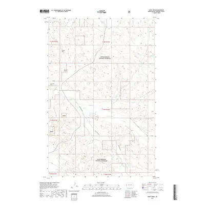
2017 Map of Sheep Creek
USGS Topo · Published 2017About this map
Little Missouri National Grassland dominates this section of McKenzie County, where the landscape is defined by a dense network of coulees and ephemeral drainage systems. The intricate topography of the North Dakota badlands is evident through numerous named draws, such as Plumb Draw, Mike Hart Draw, and Cummings Draw. These features, along with the meandering courses of Sheep Creek and Bay Cr, illustrate the complex erosion patterns characteristic of the region. The area remains largely undeveloped, with movement dictated by gravel and section-line roads like Co RD 38 and Bennie Peer Crk Rd. Isolated water sources, notably Softwater Spring, provide vital points of interest in this arid terrain, while local names like Chicken Cr and W Hay Draw Cr suggest a history of ranching and livestock movement through these protected public lands.
Find a feature on this map
24 named features on this map. Tap any name to fly to it.
Don’t see what you’re looking for? This feature index may not catch every label — zoom into the map to look around manually.
Map Details
Editions of this 2017 Sheep Creek Map
This is the sole edition of this map. No revisions or reprints were ever made.
Other maps of this area

1953 · Watford City
USGS Topo · 1:250,000

1957 · Watford City
USGS Topo · 1:250,000

1967 · Watford City
USGS Topo · 1:250,000

1972 · Horse Creek School
USGS Topo · 1:24,000

1972 · Moline School
USGS Topo · 1:24,000
1972 · Phillip Spring
USGS Topo · 1:24,000

1972 · Sheep Creek
USGS Topo · 1:24,000

1972 · Sather Lake
USGS Topo · 1:24,000
1972 · Burning Mine Butte
USGS Topo · 1:24,000
1974 · Squaw Gap
USGS Topo · 1:24,000