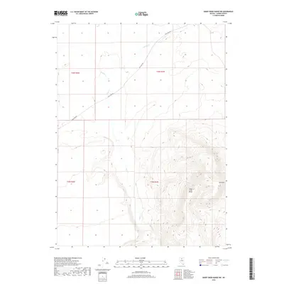
2018 Map of Sheep Creek Range NW
USGS Topo · Published 2018About this map
The Sheep Creek Range dominates the southeastern portion of this Lander County landscape, culminating in the prominent peak of Black Mtn. This high desert terrain is defined by a network of drainage systems that flow through the sagebrush and scrub, including the main channel of Rock Creek and its tributaries like Sixmile Creek and Antelope Creek. The topographic detail reveals the intricate ridgelines and canyons of the range, offering a clear look at the elevation changes across this part of the Great Basin. Rock Creek Rd provides the primary access through the northern sections, tracing a route that follows the natural contours of the valley floor. The map highlights the systematic division of the land into townships such as t36n r47e, illustrating the continuing importance of the Public Land Survey System in defining northern Nevada's ranching and resource territory.
Find a feature on this map
10 named features on this map. Tap any name to fly to it.
Don’t see what you’re looking for? This feature index may not catch every label — zoom into the map to look around manually.
Map Details
Editions of this 2018 Sheep Creek Range NW Map
This is the sole edition of this map. No revisions or reprints were ever made.
Other maps of this area

1955 · McDermitt
USGS Topo · 1:250,000

1955 · Winnemucca
USGS Topo · 1:250,000

1958 · Winnemucca
USGS Topo · 1:250,000

1959 · McDermitt
USGS Topo · 1:250,000

1962 · Winnemucca
USGS Topo · 1:250,000

1965 · Izzenhood Gap
USGS Topo · 1:24,000

1965 · Sixmile Hill
USGS Topo · 1:24,000

1965 · Sheep Creek Range SW
USGS Topo · 1:24,000

1965 · Sheep Creek Range NE
USGS Topo · 1:24,000

1965 · Sheep Creek Range SE
USGS Topo · 1:24,000