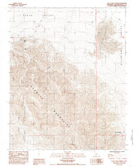
1985 Map of Sheep Creek Spring
USGS Topo · Published 1985About this map
The Ava Watz Mountains dominate this arid landscape where the southern reaches of Death Valley meet the Silurian Valley. This mid-1980s field study captures a transitional desert environment defined by sparse water sources and early mining activity. Evidence of human endeavor is found at the Sheep Cr Mine, situated near the vital Sheep Creek Spring. The western portion of the map is largely occupied by the Fort Irwin Military Reservation, marking the boundary between public land and restricted defense territory. In the southeastern corner, the presence of Old Mormon Spring (Dry) serves as a reminder of the historical significance of water to travelers through these basins, while the Salt Spring Hills and Anvil Canyon provide stark topographic contrast to the surrounding creek beds like Salt Creek.
Find a feature on this map
11 named features on this map. Tap any name to fly to it.
Don’t see what you’re looking for? This feature index may not catch every label — zoom into the map to look around manually.
Map Details
Editions of this 1985 Sheep Creek Spring Map
2 editions found
Other maps of this area

1933 · Avawatz Mountains
USGS Topo · 1:250,000

1947 · Trona
USGS Topo · 1:250,000

1948 · Red Pass Lake
USGS Topo · 1:62,500

1948 · Trona
USGS Topo · 1:250,000

1948 · Avawatz Pass
USGS Topo · 1:62,500

1951 · Avawatz Pass
USGS Topo · 1:62,500

1951 · Red Pass Lake
USGS Topo · 1:62,500

1953 · Trona
USGS Topo · 1:250,000

1956 · Silurian Hills
USGS Topo · 1:62,500

1956 · Baker
USGS Topo · 1:62,500