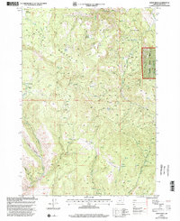
1999 Map of Sheep Ridge
USGS Topo · Published 2002About this map
Rudio Mountain dominates this portion of eastern Oregon, where a network of primitive roads and drainage basins define the high country. In this late-twentieth-century landscape, evidence of resource extraction is visible at a Quarry and a Gravel Pit near Rudio Mtn. The terrain transitions from the open slopes of Grizzly Flats to the protected boundaries of the Malheur National Forest along Sheep Ridge. Numerous high-altitude meadows like Rudio Meadows and McGrann Meadows are scattered throughout the quadrangle, serving as headwaters for the complex creek systems below. This topography is characterized by deep incisions from waterways such as Franks Creek and Pine Hollow Creek, which have carved out distinct geographic features like Timber Basin. The map captures a moment when traditional land use in the Blue Mountains intersected with modern forest management and geological survey standards.
Find a feature on this map
27 named features on this map. Tap any name to fly to it.
Don’t see what you’re looking for? This feature index may not catch every label — zoom into the map to look around manually.
Map Details
Editions of this 1999 Sheep Ridge Map
This is the sole edition of this map. No revisions or reprints were ever made.
Other maps of this area

1932 · Dayville
USGS Topo · 1:125,000

1936 · Dayville
USGS Topo · 1:125,000

1940 · Aldrich Mtn.
USGS Topo · 1:62,500

1943 · Aldrich Mtn.
USGS Topo · 1:62,500

1951 · Courtrock
USGS Topo · 1:62,500

1953 · Picture
USGS Topo · 1:62,500

1955 · Canyon City
USGS Topo · 1:250,000

1959 · Canyon City
USGS Topo · 1:250,000
1972 · Aldrich Mountain North
USGS Topo · 1:24,000
1972 · Dayville
USGS Topo · 1:24,000