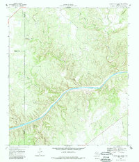
1968 Map of Sheep Run Creek
USGS Topo · Published 1985About this map
The Llano River winds through a complex network of drainage basins at the meeting point of Mason, Menard, and Kimble counties. This 1968 field-checked landscape is defined by the significant convergence of the James River and numerous perennial and seasonal streams, including Leon Creek and Sheep Run Creek. The topography reveals a highly dissected plateau where watercourses like Hogg Creek and Big Bluff Creek have carved distinct valleys into the Texas Hill Country terrain. While primarily rural and focused on the natural hydrology of the basin, the presence of a Gravel Pit and established county lines indicates the intersection of resource extraction and local administration in this limestone-rich region. Geographers can observe the intricate dendritic drainage patterns formed by Little Saline Creek, Rocky Creek, and Little Rocky Creek as they feed into the primary river systems.
Find a feature on this map
15 named features on this map. Tap any name to fly to it.
Don’t see what you’re looking for? This feature index may not catch every label — zoom into the map to look around manually.
Map Details
Editions of this 1968 Sheep Run Creek Map
2 editions found
Other maps of this area

1887 · Mason
USGS Topo · 1:125,000

1894 · Mason
USGS Topo · 1:125,000

1954 · Llano
USGS Topo · 1:250,000

1955 · Llano
USGS Topo · 1:250,000

1956 · Llano
USGS Topo · 1:250,000
1967 · Monument Mountain SE
USGS Topo · 1:24,000

1968 · Monument Mountain
USGS Topo · 1:24,000
1968 · Turtle Creek
USGS Topo · 1:24,000

1968 · Sheep Run Creek
USGS Topo · 1:24,000

1968 · London
USGS Topo · 1:24,000