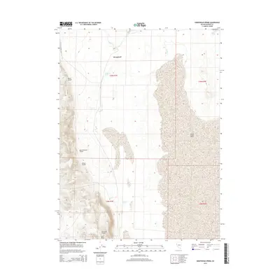
2014 Map of Sheepshead Spring
USGS Topo · Published 2014About this map
Smoke Creek Desert dominates the eastern expanse of this Washoe County landscape, where the arid basin floor meets the rising topography of the Sand Range. At the heart of this high-desert terrain lies Sheepshead, a point of historical interest situated near the vital waters of Sheepshead Spring. The map documents a rugged hydrographic network of seasonal drainages and permanent water sources, including Mocho Spring and Buckbrush Spring, which were essential for survival and livestock in this environment.
Find a feature on this map
16 named features on this map. Tap any name to fly to it.
Don’t see what you’re looking for? This feature index may not catch every label — zoom into the map to look around manually.
Map Details
Editions of this 2014 Sheepshead Spring Map
This is the sole edition of this map. No revisions or reprints were ever made.
Other maps of this area

1886 · Granite Range
USGS Topo · 1:250,000

1894 · Granite Range
USGS Topo · 1:250,000

1955 · Lovelock
USGS Topo · 1:250,000

1959 · Lovelock
USGS Topo · 1:250,000

1965 · Fox Range
USGS Topo · 1:62,500

1980 · Salt Marsh
USGS Topo · 1:24,000
1980 · Red Rock Canyon
USGS Topo · 1:24,000
1980 · Parker Canyon
USGS Topo · 1:24,000
1980 · Sand Pass
USGS Topo · 1:24,000

1980 · Hog Spring
USGS Topo · 1:24,000