
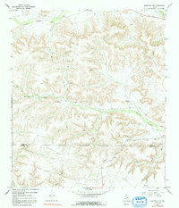
1967 Map of Sheffield NW
USGS Topo · Published 1970About this map
Deep into West Texas during the late 1960s, this area spans the Pecos Co Terrell Co line, defined by arid plateaus and an intricate network of drainage channels. The landscape is characterized by its ranching history, with established homesteads such as the Cannon Ranch, Clark Brothers Ranch, and Slaughter Ranch serving as focal points for the region’s development. The reliance on water management in this dry environment is evident through the presence of the Water Tank and Perkins Windmill, both essential for sustaining livestock and settlement across the broad draws of Lower Fourmile Draw and Sheffield Draw.
Find a feature on this map
19 named features on this map. Tap any name to fly to it.
Don’t see what you’re looking for? This feature index may not catch every label — zoom into the map to look around manually.
Map Details
Editions of this 1967 Sheffield NW Map
2 editions found
Other maps of this area

1929 · Sheffield
USGS Topo · 1:125,000

1929 · Independence Draw Quadrangle
USGS Topo · 1:125,000

1954 · Fort Stockton
USGS Topo · 1:250,000

1954 · Sonora
USGS Topo · 1:250,000

1958 · Sonora
USGS Topo · 1:250,000

1958 · Fort Stockton
USGS Topo · 1:250,000

1967 · Divide Country
USGS Topo · 1:24,000

1967 · Horsehead Canyon
USGS Topo · 1:24,000

1967 · Deer Canyon
USGS Topo · 1:24,000

1967 · Sheffield SE
USGS Topo · 1:24,000