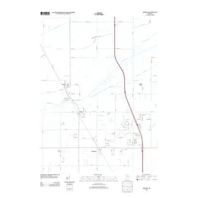
2013 Map of Shelby
USGS Topo · Published 2013About this map
The Kankakee River winds through this landscape, defining the character of a region heavily modified by an extensive drainage network. Settlements such as Shelby, Thayer, and Roselawn are linked by a grid of rural roads and water management features like Tully Ditch and Singleton Ditch. This 2013 survey illustrates the agricultural persistence of the area, evidenced by landmarks such as Scheeringa Farms. The map also captures smaller residential pockets including Forest City and the planned development around Lake Holiday. Local history enthusiasts can trace the remnants of regional transportation via Monon Rd, which follows the historic railroad alignment that once served these river towns. The intricate system of waterways, including Dehaan Ditch and Hibler Ditch, reveals the long-term engineering required to maintain the productivity of these northern Indiana lowlands.
Find a feature on this map
124 named features on this map. Tap any name to fly to it.
Don’t see what you’re looking for? This feature index may not catch every label — zoom into the map to look around manually.
Map Details
Editions of this 2013 Shelby Map
This is the sole edition of this map. No revisions or reprints were ever made.
Other maps of this area

1953 · Leroy
USGS Topo · 1:24,000

1953 · Hebron
USGS Topo · 1:24,000

1953 · Lowell
USGS Topo · 1:24,000

1953 · Chicago
USGS Topo · 1:250,000

1957 · Chicago
USGS Topo · 1:250,000

1957 · DeMotte
USGS Topo · 1:24,000

1959 · Schneider
USGS Topo · 1:24,000

1959 · Shelby
USGS Topo · 1:24,000

1962 · Parr
USGS Topo · 1:24,000
1962 · Fair Oaks
USGS Topo · 1:24,000