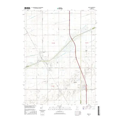
2016 Map of Shelby
USGS Topo · Published 2016About this map
The Kankakee River serves as the geographic heart of this Indiana landscape, marking the boundary between Lake, Newton, and Jasper counties. This environment is defined by an extensive network of water management features such as Singleton Ditch, Vannatti Ditch, and Dehaan Ditch, reflecting the region's history of reclaiming wetlands for agricultural use. Small communities are concentrated near the river, including Shelby and Thayer, which sit on opposite banks near the N State Rd 55 crossing. To the south, the settlement of Roselawn appears alongside the Roselawn Cem, while the Lake Holiday development is visible to the southeast. Traces of the region's transportation history are evident in Monon Rd, preserving the alignment of a significant former rail corridor that once linked the local grain elevators and rural depots to wider markets.
Find a feature on this map
94 named features on this map. Tap any name to fly to it.
Don’t see what you’re looking for? This feature index may not catch every label — zoom into the map to look around manually.
Map Details
Editions of this 2016 Shelby Map
This is the sole edition of this map. No revisions or reprints were ever made.
Other maps of this area

1953 · Leroy
USGS Topo · 1:24,000

1953 · Hebron
USGS Topo · 1:24,000

1953 · Lowell
USGS Topo · 1:24,000

1953 · Chicago
USGS Topo · 1:250,000

1957 · Chicago
USGS Topo · 1:250,000

1957 · DeMotte
USGS Topo · 1:24,000

1959 · Schneider
USGS Topo · 1:24,000

1959 · Shelby
USGS Topo · 1:24,000

1962 · Parr
USGS Topo · 1:24,000
1962 · Fair Oaks
USGS Topo · 1:24,000