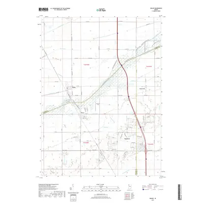
2019 Map of Shelby
USGS Topo · Published 2019About this map
The Kankakee River winds through a landscape defined by an extensive drainage network, where the borders of Lake, Newton, and Jasper counties converge. This 2019 survey documents a rural and residential environment where water management is central to the land's utility, evidenced by the numerous engineered waterways like Singleton Ditch, Brown Ditch, and Tully Ditch. The settlement of Shelby sits north of the river, while Thayer and Roselawn anchor the southern portions of the map. Residential developments such as those near Lake Holiday and along Island Blvd show the modern footprint of the area. For local historians, the inclusion of the Roselawn Cem and the naming of local corridors like Monon Rd provide specific points of reference for genealogical or community research. The map also identifies local recreational or functional spaces such as River View Field and the small cluster at Forest City.
Find a feature on this map
92 named features on this map. Tap any name to fly to it.
Don’t see what you’re looking for? This feature index may not catch every label — zoom into the map to look around manually.
Map Details
Editions of this 2019 Shelby Map
This is the sole edition of this map. No revisions or reprints were ever made.
Other maps of this area

1953 · Leroy
USGS Topo · 1:24,000

1953 · Hebron
USGS Topo · 1:24,000

1953 · Lowell
USGS Topo · 1:24,000

1953 · Chicago
USGS Topo · 1:250,000

1957 · Chicago
USGS Topo · 1:250,000

1957 · DeMotte
USGS Topo · 1:24,000

1959 · Schneider
USGS Topo · 1:24,000

1959 · Shelby
USGS Topo · 1:24,000

1962 · Parr
USGS Topo · 1:24,000
1962 · Fair Oaks
USGS Topo · 1:24,000