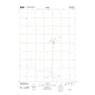
2011 Map of Shelby
USGS Topo · Published 2011About this map
Shelby anchors this portion of Polk County, sitting along the section-line grid of the Nebraska prairie. This 2011 survey illustrates the town's compact residential layout and essential community infrastructure, including the Shelby Post Office and Graceland Cemetery. The surrounding agricultural landscape is defined by the winding course of the Big Blue River to the south, where the Thelen Reservoir and Thelen Dam manage local water resources. Significant for genealogical research, the map identifies several distinct burial grounds scattered across the township, such as the Wesley Chapel Cemetery in the northwest and Palo Cemetery south of the main settlement. Large-scale livestock operations like the Golden West Feedyards contrast with the riparian zones, showing the modern industrial footprint of this rural farming region.
Find a feature on this map
25 named features on this map. Tap any name to fly to it.
Don’t see what you’re looking for? This feature index may not catch every label — zoom into the map to look around manually.
Map Details
Editions of this 2011 Shelby Map
This is the sole edition of this map. No revisions or reprints were ever made.
Other maps of this area

1896 · Stromsburg
USGS Topo · 1:125,000

1899 · David City
USGS Topo · 1:125,000

1955 · Fremont
USGS Topo · 1:250,000

1957 · Fremont
USGS Topo · 1:250,000

1958 · Fremont
USGS Topo · 1:250,000

1958 · Columbus SW
USGS Topo · 1:24,000

1958 · Silver Creek SE
USGS Topo · 1:24,000

1958 · Columbus SE
USGS Topo · 1:24,000
1965 · Stromsburg
USGS Topo · 1:24,000
1965 · Osceola
USGS Topo · 1:24,000