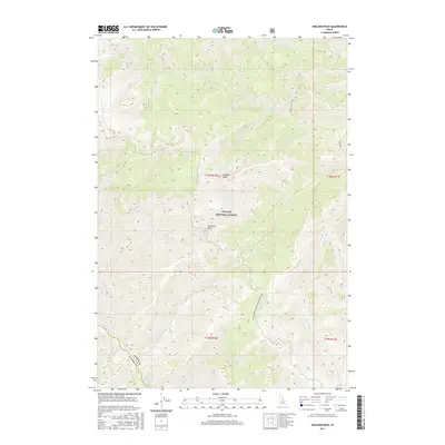
2017 Map of Sheldon Peak
USGS Topo · Published 2017About this map
Sheldon Peak dominates this high-elevation portion of the Challis National Forest at the border of Lemhi and Custer counties. The drainage network is particularly dense, defined by steep canyon waterways like S Fork Camas Cr, Fly Creek, and Mahoney Cr. The presence of Sleeping Deer Road (Winter Trail) and the Flume-S Fk Camas suggest a landscape shaped by seasonal access and historical water management. Geologists and local historians can trace the intricate topography around Fly Creek Point and the geothermal activity indicated by Shower Bath Springs near the southern edge of the quadrangle. This area of central Idaho remains a complex wilderness of named ridges and creek systems, including Snowshoe Cr and Warm Spring Cr, illustrating the hydrographic character of the region.
Find a feature on this map
23 named features on this map. Tap any name to fly to it.
Don’t see what you’re looking for? This feature index may not catch every label — zoom into the map to look around manually.
Map Details
Editions of this 2017 Sheldon Peak Map
This is the sole edition of this map. No revisions or reprints were ever made.
Other maps of this area

1930 · Casto
USGS Topo · 1:125,000

1956 · Twin Peaks
USGS Topo · 1:62,500

1957 · Challis
USGS Topo · 1:250,000

1960 · Challis
USGS Topo · 1:250,000

1963 · Challis
USGS Topo · 1:250,000

1963 · Challis Creek Lakes
USGS Topo · 1:24,000

1963 · Meyers Cove
USGS Topo · 1:24,000

1963 · Rock Creek
USGS Topo · 1:24,000
1963 · Sherman Peak
USGS Topo · 1:24,000
1963 · Sleeping Deer Mountain
USGS Topo · 1:24,000