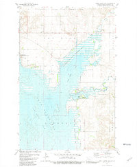
1981 Map of Shell Creek Bay
USGS Topo · Published 1981About this map
Lake Sakakawea and its sprawling Van Hook Arm dominate this North Dakota landscape, revealing the complex geography created by the impoundment of the Missouri River. The map documents the northern reaches of the Fort Berthold Indian Reservation Boundary as it interacts with the altered shoreline of Shell Creek Bay. While much of the low-lying terrain is submerged or protected within the Van Hook State Wildlife Management Area, remnants of the area's earlier history remain visible. The placement of the Van Hook Cem and the label for Van Hook 1937 serve as important markers for researchers tracing the displacement and relocation of communities following the construction of the Garrison Dam. Inland, the rural character is defined by the Parshall and Fertile townships, where a lonely Townhall and scattered Gravel Pits dot the rolling plains above the water's edge.
Find a feature on this map
27 named features on this map. Tap any name to fly to it.
Don’t see what you’re looking for? This feature index may not catch every label — zoom into the map to look around manually.
Map Details
Editions of this 1981 Shell Creek Bay Map
This is the sole edition of this map. No revisions or reprints were ever made.
Other maps of this area

1953 · Williston
USGS Topo · 1:250,000

1953 · Watford City
USGS Topo · 1:250,000

1957 · Williston
USGS Topo · 1:250,000

1957 · Watford City
USGS Topo · 1:250,000

1967 · Watford City
USGS Topo · 1:250,000

1967 · New Town SW
USGS Topo · 1:24,000

1967 · Parshall SW
USGS Topo · 1:24,000

1967 · New Town SE
USGS Topo · 1:24,000

1981 · Belden SW
USGS Topo · 1:24,000

1981 · New Town
USGS Topo · 1:24,000