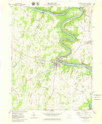
1978 Map of Shepherdstown
USGS Topo · Published 1979About this map
The Potomac River carves a winding path through this region, forming the dramatic Horseshoe Bend and Terrapin Neck before passing Shepherdstown. As a prominent river town, this 1970s landscape reflects a deep layered history of transport and education, anchored by Shepherd College and the James Rumsey Bridge. Along the Maryland shore, the Chesapeake and Ohio Canal National Historical Park follows the river's contours, a legacy of earlier commerce preserved alongside the Antietam National Battlefield Site to the northeast.
Find a feature on this map
53 named features on this map. Tap any name to fly to it.
Don’t see what you’re looking for? This feature index may not catch every label — zoom into the map to look around manually.
Map Details
Editions of this 1978 Shepherdstown Map
2 editions found
Other maps of this area

1884 · Harpers Ferry
USGS Topo · 1:125,000

1891 · Harpers Ferry
USGS Topo · 1:125,000

1893 · Harpers Ferry
USGS Topo · 1:125,000

1908 · Middletown
USGS Topo · 1:48,000

1909 · Hagerstown
USGS Topo · 1:48,000

1910 · Antietam
USGS Topo · 1:62,500

1912 · Hagerstown
USGS Topo · 1:62,500

1912 · Williamsport
USGS Topo · 1:62,500

1914 · Martinsburg
USGS Topo · 1:48,000

1916 · Martinsburg
USGS Topo · 1:62,500