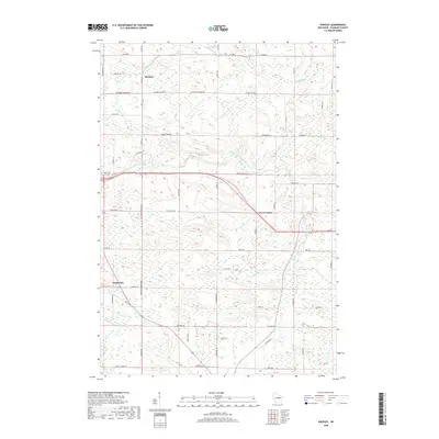
2018 Map of Shepley
USGS Topo · Published 2018About this map
The Middle Branch Embarrass River meanders through this portion of Shawano County, carving a path through a landscape defined by its complex network of small waterways and wetland pockets. Small rural clusters like Shepley and Five Corners serve as the primary landmarks in an area otherwise characterized by agricultural blocks and forested tracts. The hydrology here is remarkably dense, with tributaries such as Strassburg Cr, Wilson Cr, and Pony Cr feeding the larger river system.
Find a feature on this map
60 named features on this map. Tap any name to fly to it.
Don’t see what you’re looking for? This feature index may not catch every label — zoom into the map to look around manually.
Map Details
Editions of this 2018 Shepley Map
This is the sole edition of this map. No revisions or reprints were ever made.
Other maps of this area

1954 · Wittenberg
USGS Topo · 1:48,000

1954 · Gresham
USGS Topo · 1:48,000

1955 · Clintonville
USGS Topo · 1:48,000

1955 · Tigerton
USGS Topo · 1:48,000

1955 · Green Bay
USGS Topo · 1:250,000

1964 · Wittenberg
USGS Topo · 1:62,500

1964 · Gresham
USGS Topo · 1:62,500
1970 · Tigerton NW
USGS Topo · 1:24,000
1970 · Marion
USGS Topo · 1:24,000
1970 · Tigerton
USGS Topo · 1:24,000