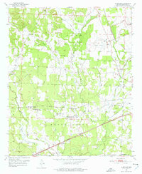
1951 Map of Sheppard
USGS Topo · Published 1977About this map
Guernsey and Sheppard serve as central hubs in this rural Arkansas landscape, situated along the tracks of the Missouri Pacific railroad. The map reveals a community structured around small churches and educational sites, such as Guernsey High Sch and Mt Sinai Ch. Numerous family-named landmarks like Wayne Chapel and Westmoreland Cem dot the terrain, offering significant value for genealogical research in Hempstead County. To the northeast, the Hope Municipal Airport and its Airway Beacon signify the region's mid-century aviation infrastructure. The hydrology is dominated by the wandering paths of Bois d'Arc Creek and Water Creek, which cut through the townships of Ozan and De Roan.
Find a feature on this map
36 named features on this map. Tap any name to fly to it.
Don’t see what you’re looking for? This feature index may not catch every label — zoom into the map to look around manually.
Map Details
Editions of this 1951 Sheppard Map
4 editions found
Other maps of this area

1951 · Blevins
USGS Topo · 1:24,000

1951 · Patmos
USGS Topo · 1:24,000

1951 · Fulton
USGS Topo · 1:24,000

1951 · Columbus
USGS Topo · 1:24,000

1951 · Sheppard
USGS Topo · 1:24,000

1951 · Spring Hill
USGS Topo · 1:24,000

1951 · Washington
USGS Topo · 1:24,000

1951 · Hope
USGS Topo · 1:24,000

1951 · Mc Nab
USGS Topo · 1:24,000

1953 · El Dorado
USGS Topo · 1:250,000