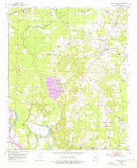
1951 Map of Spring Hill
USGS Topo · Published 1976About this map
Spring Hill serves as a central hub in this landscape where the Missouri Pacific railroad cuts through the northern timber and farmland of southern Arkansas. The map illustrates a community anchored by numerous rural institutions, including Union Ch, Mt Zion Ch, and educational sites like Williams Chapel Sch and the Stevenson Sch (Abandoned). A high density of family and community burial grounds, such as Hervey Cem and Sullivan Cem, underscores the deep genealogical roots of the area. The southwestern portion of the sheet is dominated by the shifting hydrology of the Prairie River and Lost River, where the 1916 Cut-off Lake and 1940 Cut-off-Lake mark old river channels. This terrain of ridges and flats is further defined by the Bois d'Arc Lake and the meandering path of Bois d'Arc Creek.
Find a feature on this map
36 named features on this map. Tap any name to fly to it.
Don’t see what you’re looking for? This feature index may not catch every label — zoom into the map to look around manually.
Map Details
Editions of this 1951 Spring Hill Map
3 editions found
Other maps of this area

1951 · Patmos
USGS Topo · 1:24,000

1951 · Fulton
USGS Topo · 1:24,000

1951 · Sheppard
USGS Topo · 1:24,000

1951 · Spring Hill
USGS Topo · 1:24,000

1951 · Hope
USGS Topo · 1:24,000

1951 · Mc Nab
USGS Topo · 1:24,000

1952 · Old Town
USGS Topo · 1:24,000

1952 · Fouke NE
USGS Topo · 1:24,000

1952 · Boyd Hill
USGS Topo · 1:24,000

1953 · El Dorado
USGS Topo · 1:250,000