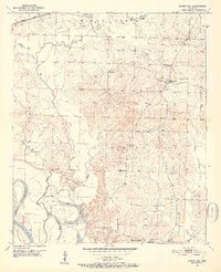
1951 Map of Spring Hill
USGS Topo · Published 1952About this map
Spring Hill and the surrounding Hempstead County countryside are detailed here during the early 1950s, revealing a landscape defined by small rural institutions and the shifting path of the Red River. A high density of country churches and family burial grounds, such as Fairview Ch and the Sullivan Cem, reflect the deep-rooted community structure of the era. To the south, the river's dynamic nature is evidenced by the 1916 Cut-off Lake and the 1940 Cut-off-Lake, which mark former channels now separated from the main flow.
Find a feature on this map
36 named features on this map. Tap any name to fly to it.
Don’t see what you’re looking for? This feature index may not catch every label — zoom into the map to look around manually.
Map Details
Editions of this 1951 Spring Hill Map
3 editions found
Other maps of this area

1951 · Patmos
USGS Topo · 1:24,000

1951 · Fulton
USGS Topo · 1:24,000

1951 · Sheppard
USGS Topo · 1:24,000

1951 · Spring Hill
USGS Topo · 1:24,000

1951 · Hope
USGS Topo · 1:24,000

1951 · Mc Nab
USGS Topo · 1:24,000

1952 · Old Town
USGS Topo · 1:24,000

1952 · Fouke NE
USGS Topo · 1:24,000

1952 · Boyd Hill
USGS Topo · 1:24,000

1953 · El Dorado
USGS Topo · 1:250,000