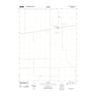
2010 Map of Sheridan Lake
USGS Topo · Published 2010About this map
Sheridan Lake serves as the central hub of this eastern Colorado landscape, reflecting the grid-based agricultural and transport structure of Kiowa County. The settlement itself is anchored by a cluster of residential and commercial structures at the junction of State Route 96 and several local arteries. To the north, the Sheridan Lake Cemetery sits in a quiet, isolated position, providing a primary point of interest for genealogists tracing local family histories. The surrounding terrain is defined by an extensive network of rural routes, including County Road T, County Road L, and County Rd-63, which partition the plains into a distinct patchwork. The namesake Sheridan Lake water body lies just south of the town, representing a significant natural feature in an otherwise strictly surveyed environment.
Find a feature on this map
12 named features on this map. Tap any name to fly to it.
Don’t see what you’re looking for? This feature index may not catch every label — zoom into the map to look around manually.
Map Details
Editions of this 2010 Sheridan Lake Map
This is the sole edition of this map. No revisions or reprints were ever made.
Other maps of this area

1890 · Granada
USGS Topo · 1:125,000

1892 · Cheyenne Wells
USGS Topo · 1:125,000

1892 · Granada
USGS Topo · 1:125,000

1894 · Cheyenne Wells
USGS Topo · 1:125,000

1894 · Granada
USGS Topo · 1:125,000

1954 · Lamar
USGS Topo · 1:250,000

1958 · Lamar
USGS Topo · 1:250,000

1968 · Stuart
USGS Topo · 1:24,000

1968 · Sheridan Lake
USGS Topo · 1:24,000
1968 · Sheridan Lake SE
USGS Topo · 1:24,000