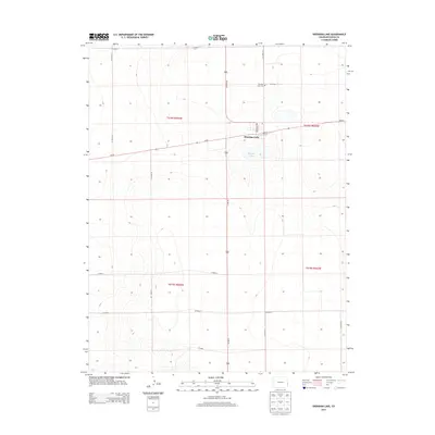
2013 Map of Sheridan Lake
USGS Topo · Published 2013About this map
Sheridan Lake serves as the primary focal point of this Kiowa County landscape, where the small agricultural settlement is anchored by a grid of streets including Main St and Colorado Ave. The eponymous Sheridan Lake water body lies just south of the town site, reflecting the importance of water resources in the high plains. A few miles north of the main residential area, the Sheridan Lake Cem provides a genealogical touchstone for local families. The map reveals a strictly organized section-line road network, dominated by routes like Co-96 and Co Road S, which support the dryland farming and ranching operations of the region. This 2013 survey documents the enduring layout of a remote eastern Colorado community where the intersection of highway and county roads remains the heart of local commerce.
Find a feature on this map
21 named features on this map. Tap any name to fly to it.
Don’t see what you’re looking for? This feature index may not catch every label — zoom into the map to look around manually.
Map Details
Editions of this 2013 Sheridan Lake Map
This is the sole edition of this map. No revisions or reprints were ever made.
Other maps of this area

1890 · Granada
USGS Topo · 1:125,000

1892 · Cheyenne Wells
USGS Topo · 1:125,000

1892 · Granada
USGS Topo · 1:125,000

1894 · Cheyenne Wells
USGS Topo · 1:125,000

1894 · Granada
USGS Topo · 1:125,000

1954 · Lamar
USGS Topo · 1:250,000

1958 · Lamar
USGS Topo · 1:250,000

1968 · Stuart
USGS Topo · 1:24,000

1968 · Sheridan Lake
USGS Topo · 1:24,000
1968 · Sheridan Lake SE
USGS Topo · 1:24,000