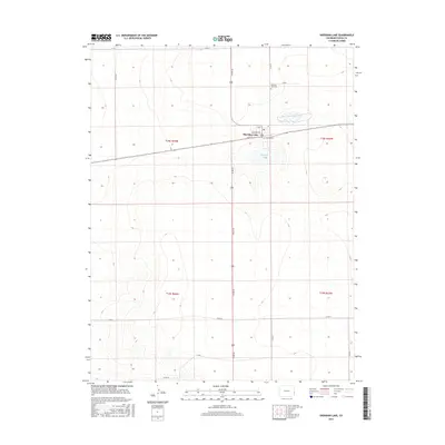
2016 Map of Sheridan Lake
USGS Topo · Published 2016About this map
The town of Sheridan Lake serves as the central hub of this eastern Colorado landscape, situated along the crossing of Highway 385 and Highway 96. This 2016 survey highlights the organized street grid of the community, featuring names like Broadway Ave, Main St, and Buffalo St. The presence of the Po and the Sheridan Lake Cem to the north provide important points of reference for genealogists and local historians tracking family roots in Kiowa County. Just south of the town center lies the namesake water body, Sheridan Lake, which punctuates the surrounding agricultural and ranching terrain. The map's layout, defined by the Public Land Survey System sections such as t18s r44w and t19s r44w, illustrates the enduring checkerboard pattern of settlement and land use common to the High Plains.
Find a feature on this map
21 named features on this map. Tap any name to fly to it.
Don’t see what you’re looking for? This feature index may not catch every label — zoom into the map to look around manually.
Map Details
Editions of this 2016 Sheridan Lake Map
This is the sole edition of this map. No revisions or reprints were ever made.
Other maps of this area

1890 · Granada
USGS Topo · 1:125,000

1892 · Cheyenne Wells
USGS Topo · 1:125,000

1892 · Granada
USGS Topo · 1:125,000

1894 · Cheyenne Wells
USGS Topo · 1:125,000

1894 · Granada
USGS Topo · 1:125,000

1954 · Lamar
USGS Topo · 1:250,000

1958 · Lamar
USGS Topo · 1:250,000

1968 · Stuart
USGS Topo · 1:24,000

1968 · Sheridan Lake
USGS Topo · 1:24,000
1968 · Sheridan Lake SE
USGS Topo · 1:24,000