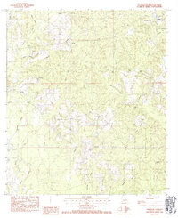
1983 Map of Sheridan
USGS Topo · Published 1984About this map
Sheridan and the surrounding pine-clad hills of Washington Parish are documented here in a detailed provisional survey from the early 1980s. This corner of Louisiana is defined by its dense network of small waterways, including Warner Creek, Thigpen Creek, and Bogue Lusa Creek, which carve through the undulating terrain. The landscape is notably dotted with small family and community burial grounds, such as Simmons Cem, Creel Cem, and Magee Cem, providing a significant spatial record for genealogists and local historians. To the northeast, the Dean Lee State Forest borders the settlement areas, while community life centers around landmarks like Poplarhead Ch and Mt Zion Ch. The presence of the Franklinton Airport and several rest areas suggests the gradual modernization of this rural timber and agricultural region.
Find a feature on this map
38 named features on this map. Tap any name to fly to it.
Don’t see what you’re looking for? This feature index may not catch every label — zoom into the map to look around manually.
Map Details
Editions of this 1983 Sheridan Map
This is the sole edition of this map. No revisions or reprints were ever made.
Other maps of this area

1939 · Zona
USGS Topo · 1:31,680

1939 · Clifton
USGS Topo · 1:31,680

1942 · Thigpen
USGS Topo · 1:31,680

1942 · Rio
USGS Topo · 1:31,680

1942 · Thomas
USGS Topo · 1:31,680

1949 · Bogalusa West
USGS Topo · 1:31,680

1950 · Folsom
USGS Topo · 1:31,680

1950 · Crains Creek
USGS Topo · 1:31,680

1950 · Franklinton
USGS Topo · 1:31,680

1953 · Mobile
USGS Topo · 1:250,000