
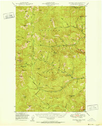
1951 Map of Sherman Peak
USGS Topo · Published 1951About this map
Colville National Forest dominates this mid-century survey of the high-elevation divide between the Sanpoil and Columbia rivers. The landscape is defined by a dense network of fire lookouts, including Jackknife Mtn, Copper Butte, Graves Mtn, Columbia Mtn, and White Mtn, reflecting the vital forest management and fire prevention infrastructure of the era. The mapping of Sherman Pass and Sherman Creek Pass documents the critical mountain crossings that connect Ferry County's eastern and western reaches.
Find a feature on this map
66 named features on this map. Tap any name to fly to it.
Don’t see what you’re looking for? This feature index may not catch every label — zoom into the map to look around manually.
Map Details
Editions of this 1951 Sherman Peak Map
2 editions found
Other maps of this area

1904 · Republic
USGS Topo · 1:125,000

1936 · Marcus
USGS Topo · 1:96,000

1942 · Marcus
USGS Topo · 1:125,000

1948 · Curlew
USGS Topo · 1:62,500

1948 · Republic
USGS Topo · 1:62,500

1948 · Sherman Peak
USGS Topo · 1:62,500

1948 · Kettle Falls
USGS Topo · 1:62,500

1948 · Orient
USGS Topo · 1:62,500

1948 · Togo Mountain
USGS Topo · 1:62,500

1950 · Inchelium
USGS Topo · 1:62,500