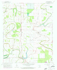
1963 Map of Sherrill
USGS Topo · Published 1973About this map
Tucker State Prison and the surrounding Tucker Prison Farm dominate the central landscape of this Jefferson County survey, which was updated in 1971. The territory is defined by the winding paths of ancient waterways including Plum Bayou, Wabbaseka Bayou, and Indian Bayou, creating a complex network of wetlands and oxbow formations like Dudley Lake and Patton Lake. The St Louis Southwestern railroad serves as the primary transportation spine, connecting the small agricultural settlements of Ferda, Tucker, and Sherrill. Numerous family and community landmarks are scattered across the fertile bottomlands, including Hendricks Cem, Fields Cem, and rural congregations such as Shady Grove Ch and Antioch Ch. Extensive engineering works, including a prominent Levee and the Main Ditch, illustrate the efforts to manage the water-rich terrain of the Bolivar and Gum Woods regions for cultivation.
Find a feature on this map
40 named features on this map. Tap any name to fly to it.
Don’t see what you’re looking for? This feature index may not catch every label — zoom into the map to look around manually.
Map Details
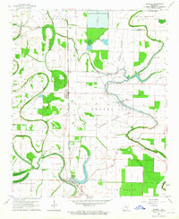
Editions of this 1963 Sherrill Map
2 editions found
Other maps of this area

1891 · Little Rock
USGS Topo · 1:125,000

1893 · Little Rock
USGS Topo · 1:125,000

1932 · Pastoria
USGS Topo · 1:62,500

1935 · Altheimer
USGS Topo · 1:62,500

1935 · Pastoria
USGS Topo · 1:62,500

1937 · England
USGS Topo · 1:48,000

1939 · Keo
USGS Topo · 1:31,680

1941 · Keo
USGS Topo · 1:31,680

1943 · England
USGS Topo · 1:62,500

1948 · Helena
USGS Topo · 1:250,000