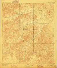
1895 Map of Sherwood
USGS Topo · Published 1910About this map
Sherwood serves as the central hub of this West Texas landscape, situated at the confluence where several waterways emerge from the surrounding tablelands. Surveyed in 1893, the map illustrates an era of early settlement defined by the availability of water in a semi-arid region. The Middle Concho River and South Concho River provide the primary drainage, while numerous smaller streams like Spring Creek and Dove Creek create a network of riparian corridors that influenced the location of early outposts. To the east, Knickerbocker sits near the Tom Green County line, while Arden occupies a position to the north along the river. Distinctive landmarks such as Lopez Peaks and the Twin Buttes break the horizon, providing essential navigational points for early residents and travelers moving through the Concho Valley long before the arrival of modern highways.
Find a feature on this map
18 named features on this map. Tap any name to fly to it.
Don’t see what you’re looking for? This feature index may not catch every label — zoom into the map to look around manually.
Map Details
Editions of this 1895 Sherwood Map
5 editions found
Other maps of this area

1891 · Hayrick
USGS Topo · 1:125,000

1892 · San Angelo
USGS Topo · 1:125,000

1893 · Fort McKavett
USGS Topo · 1:125,000

1894 · Hayrick
USGS Topo · 1:125,000

1895 · Sherwood
USGS Topo · 1:125,000

1920 · Barnhart
USGS Topo · 1:62,500

1921 · Ketchum Mountain
USGS Topo · 1:62,500

1922 · Barnhart
USGS Topo · 1:62,500

1923 · Ketchum Mountain
USGS Topo · 1:62,500

1924 · San Angelo 2-c
USGS Topo · 1:48,000