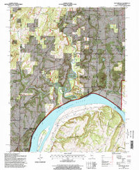
1996 Map of Shetlerville
USGS Topo · Published 1998About this map
The Ohio River dominates the southern landscape of this Pope County region, serving as the border between Illinois and Kentucky. This 1990s survey shows the industrial and recreational character of the riverbanks, anchored by the massive Smithland Lock 1 Dam and the expansive Rondeau Island. Much of the interior is managed as the Shawnee National Forest, where the topography rises into named heights like Julien Hill and War Bluff.
Find a feature on this map
60 named features on this map. Tap any name to fly to it.
Don’t see what you’re looking for? This feature index may not catch every label — zoom into the map to look around manually.
Map Details
Editions of this 1996 Shetlerville Map
This is the sole edition of this map. No revisions or reprints were ever made.
Other maps of this area

1916 · Golconda
USGS Topo · 1:62,500

1916 · Equality
USGS Topo · 1:62,500

1917 · Brownfield
USGS Topo · 1:62,500

1920 · Goloonda
USGS Topo · 1:48,000

1921 · Golconda
USGS Topo · 1:62,500

1925 · Harrisburg
USGS Topo · 1:62,500

1939 · Harrisburg
USGS Topo · 1:62,500

1949 · Paducah
USGS Topo · 1:250,000

1950 · Paducah
USGS Topo · 1:250,000

1954 · Paducah
USGS Topo · 1:250,000