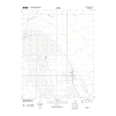
2009 Map of Shidler
USGS Topo · Published 2009About this map
Webb City and Shidler anchor this portion of the Osage County prairie, where the landscape is defined by the legacy of the regional petroleum industry. Much of the western terrain is occupied by the Burbank Oil Field, evidenced by a dense, grid-like network of access roads such as Denoya Rd and Sarge Rd. This industrial footprint is interspersed with small aviation hubs, including Cooper Ranch Airport in the northwest and Van Camp Airport just outside Shidler, reflecting the specialized transportation needs of ranching and oil operations. The natural drainage of the area is governed by several winding waterways, most notably Salt Creek and Mud Creek, along with a series of numbered reservoirs including Oknoname 113148 Reservoir. This configuration shows a rural landscape where traditional water management and modern resource extraction coexist, connected by a strictly rectilinear system of county roads.
Find a feature on this map
37 named features on this map. Tap any name to fly to it.
Don’t see what you’re looking for? This feature index may not catch every label — zoom into the map to look around manually.
Map Details
Editions of this 2009 Shidler Map
This is the sole edition of this map. No revisions or reprints were ever made.
Other maps of this area

1916 · Foraker
USGS Topo · 1:62,500

1932 · Fairfax
USGS Topo · 1:62,500

1935 · Kaw
USGS Topo · 1:62,500

1936 · Belford
USGS Topo · 1:62,500

1955 · Enid
USGS Topo · 1:250,000

1958 · Enid
USGS Topo · 1:250,000

1964 · Charley Creek NE
USGS Topo · 1:24,000

1964 · Kaw City
USGS Topo · 1:24,000
1964 · Shidler
USGS Topo · 1:24,000
1964 · Hardy
USGS Topo · 1:24,000