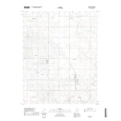
2018 Map of Shidler
USGS Topo · Published 2018About this map
Shidler and Webb City serve as the primary population centers in this northern Osage County landscape, where the geometry of Oklahoma’s Section Land Survey system is deeply etched into the road network. The map reveals a transition between small town grids and the surrounding cattle and oil country, notably evidenced by the presence of Whizbang Denoya Rd, a name that hints at the region’s early twentieth-century petroleum history and the legendary oil boomtowns that once thrived in this vicinity. Water management is a central theme, with several numbered reservoirs such as 113148 Reservoir and 13149 Reservoir dotting the terrain. Drainage follows the winding paths of Salt Creek and its many tributaries like Haines Cr and Mud Cr, which cut through the open country. This survey also documents smaller locales like Lyman and Lep, alongside a network of county routes including Sarge Creek Rd and Co Rd 4402.
Find a feature on this map
66 named features on this map. Tap any name to fly to it.
Don’t see what you’re looking for? This feature index may not catch every label — zoom into the map to look around manually.
Map Details
Editions of this 2018 Shidler Map
This is the sole edition of this map. No revisions or reprints were ever made.
Other maps of this area

1916 · Foraker
USGS Topo · 1:62,500

1932 · Fairfax
USGS Topo · 1:62,500

1935 · Kaw
USGS Topo · 1:62,500

1936 · Belford
USGS Topo · 1:62,500

1955 · Enid
USGS Topo · 1:250,000

1958 · Enid
USGS Topo · 1:250,000

1964 · Charley Creek NE
USGS Topo · 1:24,000

1964 · Kaw City
USGS Topo · 1:24,000
1964 · Shidler
USGS Topo · 1:24,000
1964 · Hardy
USGS Topo · 1:24,000