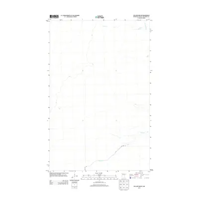
2013 Map of Shilling Dam NE
USGS Topo · Published 2013About this map
Rapid River winds through this northern landscape in Lake of the Woods County, Minnesota, defining the drainage patterns of a largely undeveloped wilderness. The map details the convergence of smaller tributaries, including Meadow Cr and the N Br Rapid River, which feed into the primary waterway as it moves toward the northeast. Human infrastructure is minimal, represented primarily by the single transit corridor of Rapid River Rd. This survey reflects the remote character of the region near the Canadian border, where the terrain is governed by hydraulic flow and seasonal wetlands rather than dense settlement. Researchers and outdoorsmen can trace the exact paths of these watercourses through the lowland forest and brush, providing a clear view of the natural hydrology of the area.
Find a feature on this map
4 named features on this map. Tap any name to fly to it.
Don’t see what you’re looking for? This feature index may not catch every label — zoom into the map to look around manually.
Map Details
Editions of this 2013 Shilling Dam NE Map
This is the sole edition of this map. No revisions or reprints were ever made.
Other maps of this area

1918 · Winterroad
USGS Topo · 1:62,500

1918 · F
USGS Topo · 1:62,500

1919 · Peppermint Creek
USGS Topo · 1:62,500

1919 · G
USGS Topo · 1:62,500

1943 · Peppermint Creek
USGS Topo · 1:62,500

1954 · Roseau
USGS Topo · 1:250,000

1957 · Roseau
USGS Topo · 1:250,000

1958 · Roseau
USGS Topo · 1:250,000
1968 · Graceton SW
USGS Topo · 1:24,000
1969 · Winter Road Lake SE
USGS Topo · 1:24,000