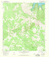
1967 Map of Shingle Hills
USGS Topo · Published 1970About this map
The boundary between Travis Co and Hays Co runs through this dissected upland landscape in the late 1960s, a region defined by the winding drainages of the Colorado River watershed. The northern edge of the sheet is dominated by the sprawling reach of Lake Travis, where the inundated valley floor meets the steep topography of the Shingle Hills. This era shows a transition toward modern infrastructure with prominent pipelines and a radio tower established alongside older land-use markers like the Peryear Cem. Several watercourses, including Barton Creek, Bee Creek, and Little Barton Creek, carve through the limestone terrain, illustrating the natural drainage patterns that have historically shaped the settlement of the Texas Hill Country. A small gravel pit and the Shield Ranch Landing Strip indicate the localized industrial and private aviation activity of the period.
Find a feature on this map
21 named features on this map. Tap any name to fly to it.
Don’t see what you’re looking for? This feature index may not catch every label — zoom into the map to look around manually.
Map Details
Editions of this 1967 Shingle Hills Map
This is the sole edition of this map. No revisions or reprints were ever made.
Other maps of this area

1887 · Blanco
USGS Topo · 1:125,000

1894 · Blanco
USGS Topo · 1:125,000

1896 · Austin
USGS Topo · 1:125,000

1897 · Austin
USGS Topo · 1:125,000

1910 · Austin
USGS Topo · 1:125,000

1930 · Austin-2
USGS Topo · 1:48,000

1930 · Blanco-1
USGS Topo · 1:48,000

1932 · Mt. Bonnell
USGS Topo · 1:62,500

1954 · Llano
USGS Topo · 1:250,000

1954 · Austin
USGS Topo · 1:250,000