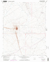
1966 Map of Ship Rock
USGS Topo · Published 1980About this map
Ship Rock rises as a dramatic monadnock over the high desert floor of the Navajo Indian Reservation, serving as the dominant geographic landmark in this corner of San Juan County. This mid-century study reveals the industrial footprint of the era, marked by a network of energy infrastructure including the Pipeline and scattered wells. The landscape is defined by the massive volcanic Dike extending southward from the main peak, a geological spine that anchors the local topography.
Find a feature on this map
13 named features on this map. Tap any name to fly to it.
Don’t see what you’re looking for? This feature index may not catch every label — zoom into the map to look around manually.
Map Details
Editions of this 1966 Ship Rock Map
3 editions found
Other maps of this area

1889 · Chaco
USGS Topo · 1:250,000

1892 · Chaco
USGS Topo · 1:250,000

1927 · Sulphur Spring
USGS Topo · 1:96,000

1928 · Kirtland
USGS Topo · 1:125,000

1932 · Kirtland
USGS Topo · 1:125,000

1934 · Ship Rock
USGS Topo · 1:62,500

1934 · Chimney Rock
USGS Topo · 1:62,500

1934 · Rattlesnake
USGS Topo · 1:62,500

1936 · Chimney Rock
USGS Topo · 1:62,500

1937 · Ship Rock
USGS Topo · 1:62,500