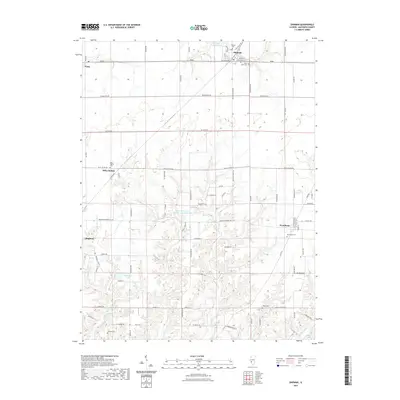
2021 Map of Shipman
USGS Topo · Published 2021About this map
Shipman and its surrounding countryside in Macoupin County are defined by a network of drainage systems and small reservoirs feeding into the larger Illinois landscape. The northern portion of the map is dominated by the Shipman Reservoir and the headwaters of Piasa Cr, while the southern reaches transition into the branching valleys of Honeycut Br and the W Fork Wood River. This terrain is dotted with significant genealogical sites, including the Shipman Cem and Saint Denis Cem on the edge of town, and more isolated locations like the Stewart Cem and Wood Cem to the south. Small, unincorporated communities and railroad-era settlements such as Miles Station, Piasa, and Woodburn remain central points of reference in this primarily agricultural region, connected by a rigid grid of county roads that navigate the complex topography created by the Evergreen Lake area and the various unnamed reservoirs.
Find a feature on this map
82 named features on this map. Tap any name to fly to it.
Don’t see what you’re looking for? This feature index may not catch every label — zoom into the map to look around manually.
Map Details
Editions of this 2021 Shipman Map
This is the sole edition of this map. No revisions or reprints were ever made.
Other maps of this area

1912 · Gillespie
USGS Topo · 1:62,500

1915 · Gillespie
USGS Topo · 1:62,500

1925 · Brighton
USGS Topo · 1:62,500

1927 · Alton
USGS Topo · 1:62,500

1927 · Edwardsville
USGS Topo · 1:62,500

1928 · Brighton
USGS Topo · 1:62,500

1932 · Edwardsville
USGS Topo · 1:62,500

1934 · Alton
USGS Topo · 1:62,500

1948 · Quincy
USGS Topo · 1:250,000
1948 · Alton
USGS Topo · 1:24,000