
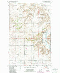
1950 Map of Shippe Canyon
USGS Topo · Published 1952About this map
The northern boundary of the Fort Peck Indian Reservation dominates the southern portion of this landscape, marking a clear line across the Sheridan County terrain. Mapped during the early 1950s as part of the Missouri River Basin development program, the area is defined by the winding course of Big Muddy Creek and the deep incisions of Shippe Canyon. The local economy of the era is evidenced by several industrial sites labeled as Coal Mines (inactive) and a lone Coal Mine (inactive) further north. These inactive excavations suggest a cycle of extraction that had already passed its peak by the time of the survey. The land is otherwise sparsely marked, with drainage features like Richardson Coulee and Otter Creek providing the primary landmarks alongside a solitary Windmill on the open range.
Find a feature on this map
11 named features on this map. Tap any name to fly to it.
Don’t see what you’re looking for? This feature index may not catch every label — zoom into the map to look around manually.
Map Details
Editions of this 1950 Shippe Canyon Map
2 editions found
Other maps of this area

1948 · Reserve
USGS Topo · 1:24,000

1948 · Alkali Coulee
USGS Topo · 1:24,000

1948 · Antelope
USGS Topo · 1:24,000

1949 · Reserve
USGS Topo · 1:24,000

1949 · Antelope
USGS Topo · 1:24,000

1949 · Alkali Coulee
USGS Topo · 1:24,000

1954 · Wolf Point
USGS Topo · 1:250,000

1958 · Wolf Point
USGS Topo · 1:250,000

1983 · Dooley SW
USGS Topo · 1:24,000

1983 · Kisler Butte
USGS Topo · 1:24,000