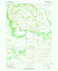
1971 Map of Shirland
USGS Topo · Published 1973About this map
The Pecatonica River and Sugar River dominate this borderland landscape, converging near the small settlements of Shirland and Harrison. In the early 1970s, this portion of Winnebago County remained primarily agricultural, defined by an intricate network of rural roads like Yale Bridge Road and Boswell Road. The Chicago Milwaukee St Paul and Pacific railroad tracks bisect the terrain, providing a steel link between the river valleys and nearby trade centers.
Find a feature on this map
49 named features on this map. Tap any name to fly to it.
Don’t see what you’re looking for? This feature index may not catch every label — zoom into the map to look around manually.
Map Details
Editions of this 1971 Shirland Map
2 editions found
Other maps of this area

1891 · Janesville
USGS Topo · 1:62,500

1893 · Janesville
USGS Topo · 1:62,500

1893 · Brodhead
USGS Topo · 1:62,500

1918 · Rockford
USGS Topo · 1:62,500

1932 · Pecatonica
USGS Topo · 1:62,500

1936 · Pecatonica
USGS Topo · 1:62,500

1938 · Rockford
USGS Topo · 1:62,500

1949 · Rockford
USGS Topo · 1:24,000

1954 · Rockford
USGS Topo · 1:250,000

1955 · Rockford
USGS Topo · 1:250,000