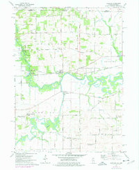
1971 Map of Shirland
USGS Topo · Published 1977About this map
The Pecatonica River meanders sharply across this northern Illinois landscape, joined by the Sugar River and Raccoon Creek near the border of Rock County and Winnebago County. At this time in the early 1970s, the rural character of the region is defined by the small settlements of Shirland and Harrison, interconnected by a network of named country roads such as Boswell Road and Principal Meridian. This survey captures the transition of the local economy, where traditional extractive industries like the many scattered Quarries and Gravel Pits exist alongside newer recreational spaces like the Laona Forest Preserve. Genealogists and local historians can locate specific landmarks including the Boys Farm School, the Shirland Cem, and the Phillips Cem. The transit corridor is dominated by the Chicago Milwaukee St Paul and Pacific railroad, while small aviation facilities like the Smith Landing Strip suggest a reliance on private air travel for this agricultural community.
Find a feature on this map
50 named features on this map. Tap any name to fly to it.
Don’t see what you’re looking for? This feature index may not catch every label — zoom into the map to look around manually.
Map Details
Editions of this 1971 Shirland Map
2 editions found
Other maps of this area

1891 · Janesville
USGS Topo · 1:62,500

1893 · Janesville
USGS Topo · 1:62,500

1893 · Brodhead
USGS Topo · 1:62,500

1918 · Rockford
USGS Topo · 1:62,500

1932 · Pecatonica
USGS Topo · 1:62,500

1936 · Pecatonica
USGS Topo · 1:62,500

1938 · Rockford
USGS Topo · 1:62,500

1949 · Rockford
USGS Topo · 1:24,000

1954 · Rockford
USGS Topo · 1:250,000

1955 · Rockford
USGS Topo · 1:250,000