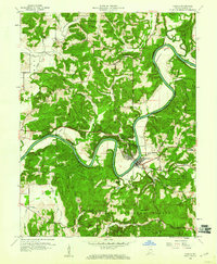
1960 Map of Shoals
USGS Topo · Published 1973About this map
The East Fork White River dictates the landscape here, carving a dramatic serpentine path through Martin County. This 1960 revision, based on earlier surveys, highlights the tight oxbow at Heathen Bend and the riverside communities of Shoals and Ironton. The Baltimore and Ohio railroad corridor follows the river valley, a vital artery for the region's movement.
Find a feature on this map
93 named features on this map. Tap any name to fly to it.
Don’t see what you’re looking for? This feature index may not catch every label — zoom into the map to look around manually.
Map Details
Editions of this 1960 Shoals Map
3 editions found
Other maps of this area

1935 · Oolitic
USGS Topo · 1:48,000

1942 · Oolitic
USGS Topo · 1:62,500

1948 · Huron
USGS Topo · 1:24,000

1950 · Huron
USGS Topo · 1:24,000

1950 · Shoals
USGS Topo · 1:24,000

1950 · Odon
USGS Topo · 1:24,000

1951 · Hillham
USGS Topo · 1:24,000

1956 · Alfordsville
USGS Topo · 1:24,000

1956 · Loogootee
USGS Topo · 1:24,000

1956 · Rusk
USGS Topo · 1:24,000