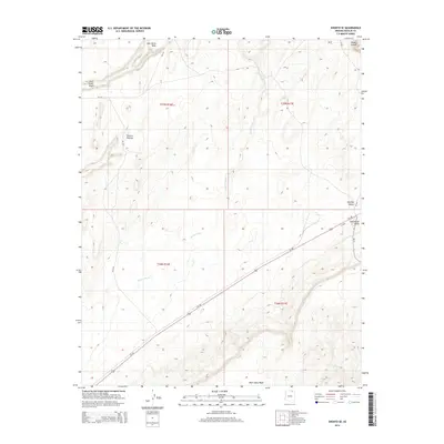
2014 Map of Shonto SE
USGS Topo · Published 2014About this map
Shonto Plateau dominates the high ground of this landscape, its expansive surface carved by drainage systems like John Smith Wash and the prominent Shonto Wash. The map illustrates the geographical transition from these elevated terrains into the deep basins of Klethla Valley and Long House Valley, where modern transit corridors like Us-160 follow the natural path of the land. In the southern reaches, Black Mesa Wash flows along the base of the rising escarpments. The placement of routes such as Bia-6312 and Bia-221 reflects the essential infrastructure connecting this portion of the Navajo Nation. This 2014 survey records a desert environment where seasonal watercourses and valley floor access determine the movement through the canyon country, including the secluded House Canyon in the northeast.
Find a feature on this map
16 named features on this map. Tap any name to fly to it.
Don’t see what you’re looking for? This feature index may not catch every label — zoom into the map to look around manually.
Map Details
Editions of this 2014 Shonto SE Map
This is the sole edition of this map. No revisions or reprints were ever made.
Other maps of this area

1883 · Marsh Pass
USGS Topo · 1:250,000

1892 · Marsh Pass
USGS Topo · 1:250,000

1956 · Marble Canyon
USGS Topo · 1:250,000

1959 · Marble Canyon
USGS Topo · 1:250,000

1961 · Marble Canyon
USGS Topo · 1:250,000

1968 · Marsh Pass
USGS Topo · 1:24,000

1970 · Black Mesa Wash NW
USGS Topo · 1:24,000

1970 · Shonto SE
USGS Topo · 1:24,000
1970 · Betatakin Ruin
USGS Topo · 1:24,000
1970 · Shonto
USGS Topo · 1:24,000