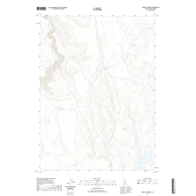
2020 Map of Shoofly Springs
USGS Topo · Published 2020About this map
Shoofly Springs serves as a focal point for this arid Owyhee County landscape, where water management is the primary marker of human presence. The terrain is defined by a network of drainage systems and man-made impoundments essential for ranching and land use in this part of Idaho. Major drainages like Battle Cr and Shoofly Cr cut through the topography, while a series of reservoirs including Eds Defeat Reservoir, Owens Reservoir, and Willow Cr Reservoir illustrate the efforts to capture seasonal runoff. These water features, along with Harris Cr Reservoir and Bybee Reservoir in the eastern and southern reaches, dictate the movement and utility of the land. The map provides a detailed view of the high-desert hydrologic system, showing how ephemeral flows like Yatahoney Cr are utilized in a region where every spring and creek carries significance for local history and survival.
Find a feature on this map
14 named features on this map. Tap any name to fly to it.
Don’t see what you’re looking for? This feature index may not catch every label — zoom into the map to look around manually.
Map Details
Editions of this 2020 Shoofly Springs Map
This is the sole edition of this map. No revisions or reprints were ever made.
Other maps of this area

1955 · Jordan Valley
USGS Topo · 1:250,000

1957 · Jordan Valley
USGS Topo · 1:250,000

1958 · Jordan Valley
USGS Topo · 1:250,000
1971 · Flying H Ranch
USGS Topo · 1:24,000
1971 · Jarvis Pasture
USGS Topo · 1:24,000

1971 · Ross Lake
USGS Topo · 1:24,000
1972 · Frying Pan Basin
USGS Topo · 1:24,000

1972 · Turner Table
USGS Topo · 1:24,000
1972 · Nichol Flat
USGS Topo · 1:24,000
1972 · Shoofly Springs
USGS Topo · 1:24,000