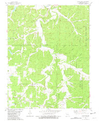
1981 Map of Short Bend
USGS Topo · Published 1981About this map
The Meramec River winds through the heart of this Dent County landscape, defining a region where water and relief create a complex network of hollows and springs. In the late 1970s, the small settlement of Short Bend served as a local focal point near the northern river bend, while the surrounding hillsides are dotted with legacy sites including Kent Chapel and New Home Ch. The map reveals a deeply etched topography where Dry Valley Creek and Spring Creek converge, feeding into the larger river system.
Find a feature on this map
59 named features on this map. Tap any name to fly to it.
Don’t see what you’re looking for? This feature index may not catch every label — zoom into the map to look around manually.
Map Details
Editions of this 1981 Short Bend Map
This is the sole edition of this map. No revisions or reprints were ever made.
Other maps of this area

1928 · Meramec Spring
USGS Topo · 1:62,500

1932 · Steelville
USGS Topo · 1:48,000

1933 · Steelville
USGS Topo · 1:62,500

1937 · Steelville
USGS Topo · 1:62,500

1941 · Salem
USGS Topo · 1:62,500

1941 · Stone Hill
USGS Topo · 1:62,500

1945 · Salem
USGS Topo · 1:62,500

1945 · Stone Hill
USGS Topo · 1:62,500

1949 · Rolla
USGS Topo · 1:250,000

1949 · Meramec Spring
USGS Topo · 1:62,500