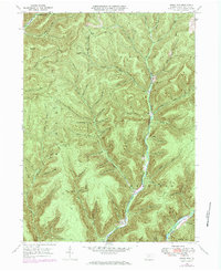
1971 Map of Short Run
USGS Topo · Published 1984About this map
Cross Fork and Kettle Creek carve deep valleys through the high plateaus of Potter County, defining a landscape of narrow hollows and steep ridges like Bunnell Ridge and Hogback Ridge. The small settlements of Short Run and Abbott sit at the junction of mountain streams, where the drainage patterns of the E Fork Sinnemahoning meet the complex network of "runs" that feed the regional rivers. The presence of the Splash Dam Trail in the northwest corner suggests the historical legacy of the lumber industry, where dams once controlled water flow to move timber downstream. Local landmarks like Elk Lick Knob and Pine Hill rise above numerous family-named and descriptive features, including Twin Sisters Hollows, Mud Lick Hollow, and Gravel Lick, reflecting a rural mountain geography deeply rooted in 19th and early 20th-century land use.
Find a feature on this map
72 named features on this map. Tap any name to fly to it.
Don’t see what you’re looking for? This feature index may not catch every label — zoom into the map to look around manually.
Map Details
Editions of this 1971 Short Run Map
This is the sole edition of this map. No revisions or reprints were ever made.
Other maps of this area

1943 · Hyner
USGS Topo · 1:62,500

1946 · Young Womans Creek
USGS Topo · 1:24,000

1946 · Renovo East
USGS Topo · 1:62,500

1946 · Renovo West
USGS Topo · 1:62,500

1946 · Hammersley Fork
USGS Topo · 1:24,000

1946 · Tamarack
USGS Topo · 1:24,000

1947 · Conrad
USGS Topo · 1:62,500

1947 · Galeton
USGS Topo · 1:62,500

1947 · Conrad
USGS Topo · 1:24,000

1947 · Short Run
USGS Topo · 1:24,000
Featured Places
- Abbott Township, PA
- Wharton Township, PA
- Summit Township, PA
- Gravel Lick, Stewardson Township
- Stewardson Township, PA