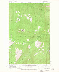
1969 Map of Shorty Peak
USGS Topo · Published 1971About this map
The high Selkirk crest in Boundary County defines this mountainous landscape, where the northern border of the Kaniksu National Forest meets the international boundary between the United States and Canada. This 1969 field-checked survey reveals a backcountry defined by elevation and water, anchored by the 6,500-foot summit of Shorty Peak and the high waters of Canyon Lake. A complex network of drainage basins, including Smith Creek, Shorty Creek, and Italian Creek, flows through deep valleys separated by prominent landmarks like Lone Tree Peak, Red Top, and Silver Mtn. This era of the forest is characterized by seasonal access and remote resource management, evidenced by the prevalence of a pack trail and jeep trail over established roads. These routes connect high-altitude points such as Italian Peak and Cutoff Peak, tracing a terrain that remained largely wild and undeveloped during the late 1960s.
Find a feature on this map
22 named features on this map. Tap any name to fly to it.
Don’t see what you’re looking for? This feature index may not catch every label — zoom into the map to look around manually.
Map Details
Editions of this 1969 Shorty Peak Map
This is the sole edition of this map. No revisions or reprints were ever made.
Other maps of this area

1911 · Priest Lake
USGS Topo · 1:250,000

1913 · Priest Lake
USGS Topo · 1:250,000

1958 · Sandpoint
USGS Topo · 1:250,000

1963 · Sandpoint
USGS Topo · 1:250,000

1968 · Smith Falls
USGS Topo · 1:24,000

1969 · Grass Mountain
USGS Topo · 1:24,000
1969 · Caribou Creek
USGS Topo · 1:24,000

1969 · Pyramid Peak
USGS Topo · 1:24,000
1969 · Smith Peak
USGS Topo · 1:24,000
1983 · Bonners Ferry
USGS Topo · 1:100,000